a type of magnetic survey instrument used in geophysics to measure variations in the Earth’s magnetic field. It operates based on the proton precession principle,
Mineral exploration
Helps in identifying ore bodies with distinct magnetic properties.
Geological mapping
Used to study subsurface structures and tectonic features.
Archaeological surveys
Detects buried artifacts and ruins with magnetic signatures.
Environmental studies
Assists in locating buried waste or monitoring subsurface changes.
Oil and gas exploration
Helps in mapping sedimentary basins.
Volcanic and earthquake studies
Provides insights into magma chambers and fault systems.
OUR INSTRUMENTS
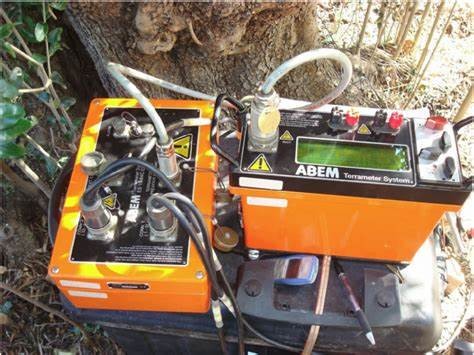
ABEM Terrameter SAS 1000
For Resistivity and IP Surveys: This instrument is known for its robust design and ability to perform vertical electrical sounding (VES), 2D and 3D imaging, and borehole logging.
ABEM Terrameter SAS 300
Enhances borehole logging capabilities. It is known for resistivity, induced polarization (IP) and self-potential (SP),
PQWT GT500
is an auto-analysis geophysical detector primarily used for underground water detection and geological surveys. It operates based on the natural electric field frequency selection method, making it effective for identifying groundwater sources, geological structures, mineral veins, tunnels, cavities, and landslides.
PQWT TC200
Geophysical prospecting instrument primarily used for underground water detection. It operates based on the natural earth field source method, eliminating the need for an external power supply. This makes it lightweight and easy to use in the field.
PASI Gea24 Seismograph
24-channel seismograph designed for geophysical surveys, particularly in seismic exploration. It is widely used for:
Refraction and shallow reflection surveys – Helps in mapping subsurface layers.
Surface wave analysis – Supports techniques like MASW, ReMi, Vs30, and ESAC.
HVSR and vibration studies – Useful for environmental and structural assessments.
Borehole Camera
a specialized geophysical tool used for downhole imaging in wells, boreholes, and underground cavities.